Bargain Basement Prices!
Colorado's biggest oil and gas lease sale in fifteen years moved 134,000 acres of public land. And most of it went for the lowest price the law allows.

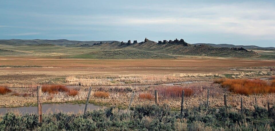
Earlier this week, on June 16, the Bureau of Land Management held the largest oil and gas lease sale Colorado has seen in more than fifteen years. By the agency’s own accounting, it was a banner day: 147 parcels leased, representing 134,173 acres and $35,264,153 in receipts. Their press release framed it the way these things are always framed these days—domestic energy, economic security, and yet another state doing its part to “unleash American energy.” But the headline revenue number hides the more interesting story, one you only find when you sort the parcels and do some basic math—no small feat for a “words guy” like me.
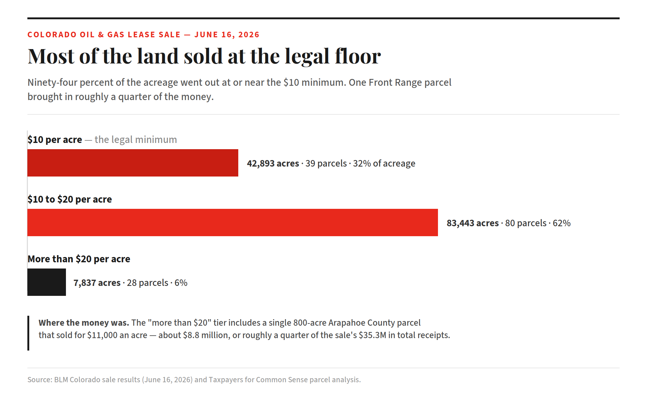
Let’s start at the top: A single 800-acre parcel in Arapahoe County, on the productive Front Range, went for $11,000 an acre. That one parcel brought in roughly $8.8 million—about a quarter of the entire sale’s proceeds, off six-tenths of one percent of the land made available on Tuesday for bidding. Leases in Weld County, the state’s most productive federal oil field, averaged around $3,000 an acre. That is what a competitive bid is supposed to look like: companies paying real money for access to ground they intend to drill.
Now let’s go to the bottom, which represents almost all of the acreage that received bids this week. Thirty-nine parcels covering 42,893 acres sold for $10 an acre, the legal minimum. That’s the floor below which the government cannot go. Another 80 parcels, covering 83,443 acres, sold for somewhere between $10 and $20—pretty darn close to the legal minimum. Add those two tiers together and you get 119 parcels spanning 126,336 acres: 94 percent of all the land leased that day, sold at or near the floor price.
So the structure of this record-breaking sale is roughly this: a handful of parcels near real areas of production generated meaningful revenue, while the vast majority of the acreage—most of it in rural Moffat Country and the part that made the sale “historic”—went out the door for, well, about the same $10 suggested reader donation for RE:PUBLIC, per acre, per year. (Full disclosure: I think you get a much better ROI with a donation to RE:PUBLIC.)
In real estate, there’s a word for buying land you have no near-term plan to develop, at the lowest price the law allows: speculation. And we have seen this move recently, in a state just one corner crossing away. A few weeks ago I recorded an Instagram Reel about a proposed December 2026 BLM lease sale in northwestern Arizona—nearly 79,000 acres. It will be the first lease sale there since 2018, in a state with zero proved oil reserves. (Credit where credit is due: my reel was entirely based on some great reporting in the Arizona Republic.)
Geologists were openly baffled. “I’m perplexed by this, to be honest. I’m confused that they would be looking for oil here,” geology professor Ryan Porter told reporter Joan Meiers. “Definitely the area around the Grand Canyon, the geology is just not very conducive to [oil and gas].”
There have been exploratory wells drilled in the area in question before, but they came up empty, which is generally taken as evidence that there is nothing to find. The Arizona case is fodder for a black comedy: drilling proposed where there is no oil. (We’ll be watching for who bids on it in December.)
What just happened in Colorado is a little different. Some of the Moffat County ground has a real gas history, and operators are pursuing horizontal oil wells in area. This isn’t Arizona’s “nothing here,” but it’s arguably more consequential—a flood of marginal acreage moving at rock bottom prices because the law now makes it nearly free to acquire and hold.
That’s the throughline, and as usual, understanding it starts by looking back at the One Big Beautiful Bill Act, signed last summer. The OBBBA did several things at once, all of them likely prescribed by oil and gas industry lobbyists: cut the federal onshore royalty rate from 16.67 percent back to 12.5 percent (reducing the government’s revenue); eliminated the per-acre fee that used to discourage companies from speculation; mandated a minimum of four lease sales a year in Colorado and eight other states; and stripped local BLM land managers of the discretion to simply decline to offer a nominated parcel.
That last piece is the part most coverage misses, because procedure isn’t sexy to write about. The floor-price bids—just like the recent no-bids in the Arctic National Wildlife Refuge—are a giant tell that the BLM isn’t running all these lease sales because industry is clamoring for this specific ground. The real reason these lease sales keep taking place is because the agency is legally obligated to offer up new lease sales in eight states on a quarterly schedule. What’s more, nominated parcels must be offered, and the discretion that once let a regional BLM land manager weigh, say, sage-grouse protections or a migration corridor against an oil company’s wish list has been legislated away.
Which brings us to what, exactly, was sold at $10 an acre. More than two-thirds of the acreage sits in the northwestern corner of the state in Moffat County, which bills itself as the Elk Hunting Capital of the World. More than a hundred of the parcels overlap elk, pronghorn, and mule deer migration corridors that run north into Wyoming. About two-thirds of the land lies just south of Dinosaur National Monument, one of fewer than fifty certified International Dark Sky Places in the country—a designation that bright lights and truck traffic could put at risk. Colorado Parks and Wildlife protested ten parcels that overlap conservation easements the state and its partners bought specifically to protect sage-grouse, elk, big game, and cutthroat trout. One conservation leader called the sale a ”sweeping insult to Colorado.”
Here is the part that should give every reader pause, regardless of where they sit politically: locals have been virtually cut out of the decision making. Moffat County voted roughly 80 percent for Donald Trump in 2024, and this is not a place that resents resource development. But many locals also depend on the hunting and outfitting economy that the same drilling threatens. Both things are true at once, and the people living inside that contradiction didn’t get much of a say in which economy to prioritize—the OBBBA saw to that.
Ultimately, that’s the real cost of this kind of industry speculation. A floor-price bid is a company keeping its options open, virtually for free, while the public’s options close. Once that ground is leased, extraction becomes the dominant use, and the wilderness, the habitat, the dark sky, the elk—all of it becomes secondary. And the discretion to protect any of it, the thing that made these public lands genuinely public, is gone for the duration.
Update: Grand Staircase Survives on a Technicality
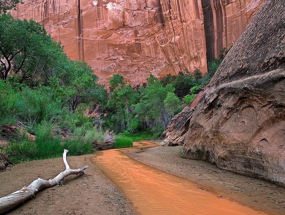
On June 11, the 60-legislative-day window for Utah’s congressional delegation to fast-track its repeal of the Grand Staircase-Escalante management plan expired, dropping the measure below its simple-majority shortcut and into filibuster territory its sponsors—Senator Mike Lee and Representative Celeste Maloy—can’t overcome. The plan governing nearly two million acres survives—for now.
It’s worth reexamining the blunt instrument that was used to attempt to kill it. The Congressional Review Act dates to 1996, built to let Congress quickly veto by simple majority an individual federal regulation made at the last minute by the previous administration. For two decades it almost never came into play, only being used successfully once, in 2001, to overturn the Occupational Safety and Health Administration’s (OSHA) ergonomics rule.
More recently, it has emerged as a favored instrument for wiping out the Biden administration’s comprehensive land management plans. In 2025, Congress first used it to overturn BLM land-use plans in Montana, North Dakota, and Alaska, on the novel theory—blessed by Government Accountability Office opinions—that a comprehensive place-based management plan is a “rule.” And earlier this year, Congress used the CRA to overturn mining restrictions just outside the Boundary Waters in Minnesota.
The Grand Staircase maneuver was serious escalation—the CRA as nuclear option. It would have been the first time the CRA was ever used to erase a national monument’s plan. And the mechanism and precedent matters. Because the CRA bars an agency from reissuing anything “substantially similar” to what it kills, success in this case would have mandated a reversion to an older plan written for a monument half the current size—wiping out years of public input and the monument’s first formal framework for tribal co-stewardship.
None of that means Lee and Maloy’s resolution had no constituency. Finalized in the last days of the Biden administration, the Grand Staircase management plan tightened grazing options and locked in binding limits over the objections of state and local officials, and those grievances are real. But the CRA would have not only deleted the plan, but essentially forbid a sensible replacement.
We don’t know yet why the clock ran out before a vote reached the floor. It’s likely that the overwhelming support for national monuments among voters gave other Senators pause. Either way, we’d like to think June 11 marks the logical endpoint for this use of the CRA. Whatever you make of the Grand Staircase plan, a tool that lets a bare majority permanently erase a land-use plan is a bad deal for whichever party is in the minority. The power to void a conservation plan today is the power to void a drilling plan tomorrow, the moment the Senate flips. Used this way, the CRA only guarantees chaos and mismanagement.
The Looooooooong Walk

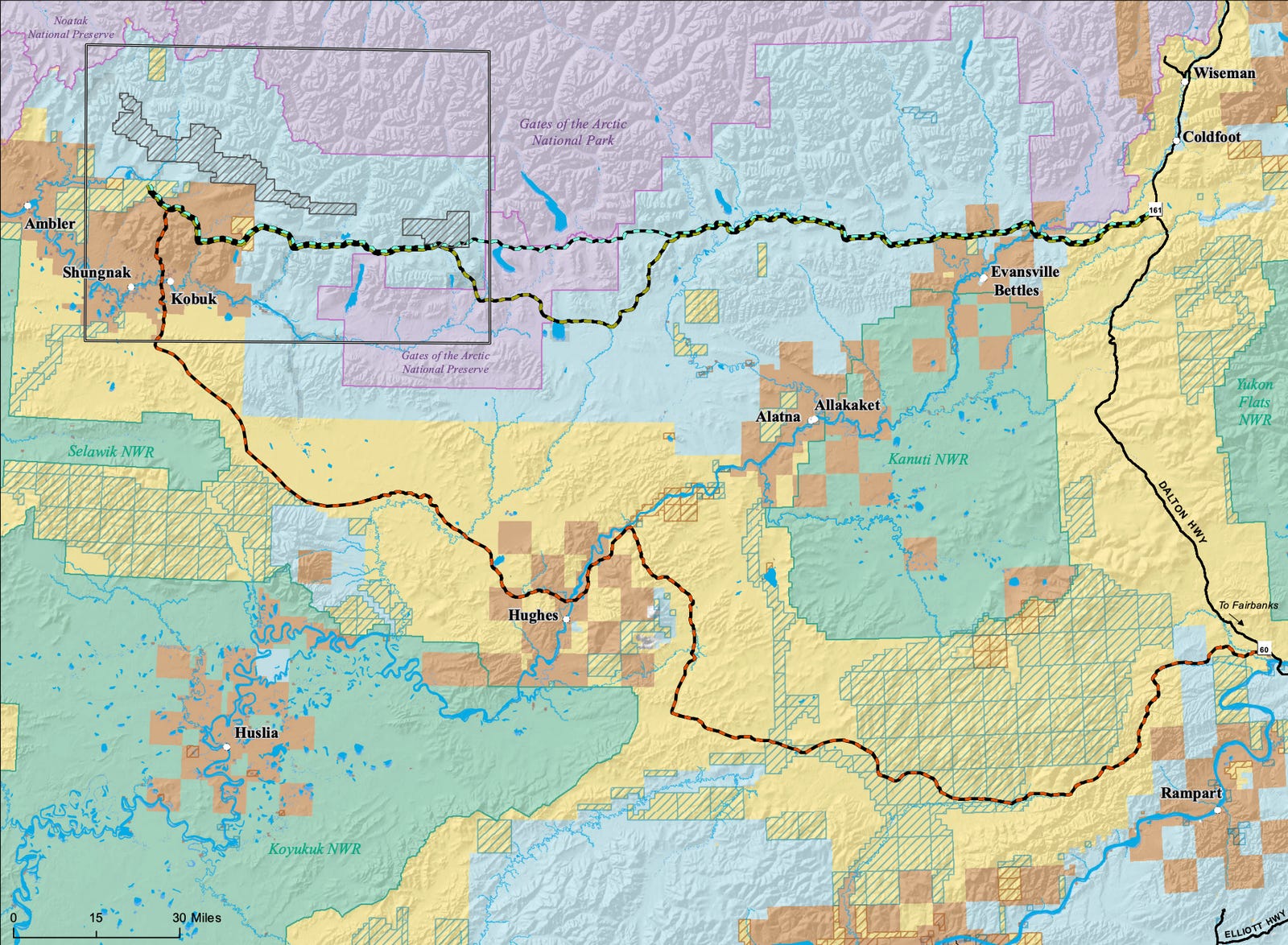
On Monday, a three-person film crew set out on foot to traverse roughly 211 miles of Alaska wilderness—following the exact route of the proposed Ambler Road Project, the nearly billion-dollar industrial corridor approved last fall to enable a foreign-owned company to establish a copper mine. I caught up with Robert Lester, the expedition’s leader, a few days before departure to talk about why he’s doing it, how you plot a route that has no trail and no map file, and what 2,900 stream crossings does to a person’s idea of “a good walk.” (A happy coincidence brought us together: At RE:PUBLIC, we’d been quietly exploring a similar story project on the very same route, and discovered Lester after approaching the same funding source. More on that at a later time.)
Let’s start with the obvious one—where did the idea come from?
I’d heard of the Ambler Road before, but I hadn’t put much into it until it got reapproved back in October. The actual spark was an Outside article—and what struck me was that the photos with [the story] weren’t even of the area. They were generic Arctic shots. And I thought, Man, it would be so valuable if we could give people a way to feel connected to this specific place.
I’m from Montana, and people think about Alaska the way they think about my state—like it’s a place where, if there’s development, there’s nobody around, so it doesn’t bother anybody. People associate anywhere away from a city with barren, as opposed to wild. I figured if we could give people a chance to actually experience this landscape and see what it’s truly like, then they have a chance to actually care.
And if they see it and still don’t care?
Then I’m totally fine with that. Honestly. But I feel like without being able to experience these places, people can’t make a real informed decision. I just think [Americans] should be able to actually see it first, and then say it’s not worth saving.
You’re following the road’s exact route, not the easier path along the rivers. Why does that matter?
A lot of people who’ve looked at doing this use the rivers—walk to a village, take the river up, get back to the route. We wanted to follow the exact land the road is set to follow because then we can show it in the film: we’re standing in a bog, and this is where they want to put the road. How are you going to build a road here? What’s the actual cost going to be?
They’re estimating almost a billion dollars. But what government project has ever come in under budget? I think there’s real power in being able to say, This is exactly where the road is supposed to go—you’re going to build it right here? I don’t think so.
How do you even start plotting a route like this?
There’s no KMZ file, no GPS track for the route—none of that exists. What there is, is a topo map from the Alaska Department of Natural Resources showing the corridor. So step one was taking that topo and converting it into a digital file we could actually work from. That got the line drawn. From there it’s been talking to the people who worked on my last film, bringing them along, and figuring out the logistics—mostly food and resupply.
This isn’t your first long traverse.
No. I canoed from Butte, Montana, where I grew up, to the Pacific Ocean—a 52-day trip. So I have some idea of what I am getting into.
What are you most worried about?
Two things. First, the water. The Tanana Chiefs Conference estimates around 2,900 stream crossings out there, and when you look at the map, that’s exactly what it looks like—very marshy, very wet. There are also 13 crossings big enough that we’ll need the packrafts for sure.
Second, there are no trails, so anytime we’re moving we’re bushwhacking. We’re most worried about the alder groves. With willows you can kind of part your way and swim through, but alder is where you’re crawling up, over, and under, getting your pack yanked the whole time. That’s where the real struggle comes in.
We’re aiming for about 10 miles a day—call it 21 days of walking, maybe 25 with some rest days.
Lester and his crew are out there now; they hope to have a film completed by the fall. We’re aiming to share dispatches—a few images and words—from the route as they go, terrain and satellite signal permitting, plus a mid-trip check-in. Stay tuned.
The Good, the Bad, and the Ugly
Every Friday, our team shares critical stories about public lands from around the internet. This list could be exhaustive and exhausting, but our intent is to inform, not overwhelm. Instead, we choose three to five important stories you should be aware of—including at least one piece of good news.
The Good: Box Elder County passes moratorium on future data centers (Utah Public Radio). “The moratorium gives officials six months to study how data centers and the infrastructure that powers them should be regulated and whether additional zoning and development standards are needed. This includes whether future projects should be allowed in unincorporated areas of the county and if so, what regulations should govern them. The pause, however, does not affect the Stratos Project, a proposed hyperscale data center campus backed by celebrity investor Kevin O’Leary that could span roughly 20,000 acres near the northern tip of the Great Salt Lake, according to county officials.”
The Bad: Trump administration will bypass environmental laws for border project in Big Bend National Park (The Big Bend Sentinel). “The Trump administration is once again bypassing federal environmental laws to speed up work on border barriers and related infrastructure in the Big Bend region of West Texas, this time for a project in and around the region’s namesake national and state parks. According to a preliminary federal notice released Monday, the latest regulatory waiver will apply to more than 100 miles of the U.S.-Mexico border in the region, from near the Closed Canyon trail in Big Bend Ranch State Park through the entirety of Big Bend National Park and into remote parts of southeastern Brewster County.”
The Ugly: Top Interior Official Met With Former Clients Before Intervening To Delay Wolf Release (Public Domain). “A scandal-plagued top official at the Interior Department met with former legal clients from the ranching industry before personally intervening to halt a release of endangered Mexican gray wolves last year, according to records reviewed by Public Domain. The records provide perhaps the most concrete example of Karen Budd-Falen’s involvement in grazing-related policy before she received a controversial ethics waiver in March 2026 that gave her wide latitude to work on grazing issues.”
Appreciate the clear breakdown of the lease sale numbers and the policy backdrop. The fact that 94% of the acreage moved at or near the $10 minimum does read as turning large swaths of public land into very low-cost options for industry.
Having spent years around Colorado’s energy and business community... mostly through my partnership in a long-running neighborhood restaurant in Cherry Creek, where I poured wine for board members at their annual meetings... I’ve seen how many of the successful independents build real companies that started by taking calculated risks on acreage when carrying costs were higher and the path to production required real work and capital.
The man I knew best, was a local example of someone who built from that kind of foundation vs earning his position the old way, by putting real skin in the game when the economics demanded it.
What stands out in the current setup is how recent rule changes appear to have flattened the risk/reward curve so dramatically that holding speculative positions now carries almost no downside for the lessee, while the public absorbs the opportunity cost and any future impacts. It’s worth asking whether the goal is still actual development or simply inventory accumulation at minimal expense.